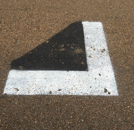
Mystery Solved: Strange Markings Part of TxDOT Survey for I-10 Expansion

By ANDY BEHLEN
Those funny road markings that showed up along Interstate 10 over the last couple weeks weren't put there by aliens, but they were put there by the government. And they aren't part of some conspiracy to confiscate peoples' guns or an ISIS invasion, as some have speculated. According to the Texas Department of Transportation, the markings are for an aerial maping survey being conducted as part of a possible Interstate 10 expansion.
When the Record asked the regional TxDOT office in Yoakum about the marks on Wednesday, agency spokesperson Cari Hensley said no one in her office knew who painted them or what they were for, although Hensley said engineers in the office speculated that they were part of a mapping survey.
TxDOT apparently suffered a communication hiccup, as Hensley told the Record on Friday that they are part of a project being conducted by the agency's San Antonio office.
"The San Antonio office is working on necessary plans for the possible expansion of I-10, the marks are aerial survey marks," Hensley said. "We are very early in the planning process, the Yoakum office was aware that San Antonio was doing this work, but apparently it is new survey technology with new markings that our district did not recognize."
Curiously, county and city officials were left in the dark about the project as well.
A witness in Schulenburg reported seeing a work crew painting the marks earlier this week. The witness said the workers' truck had the name SAM Engineering writen on the side of it. The Record contacted the firm Surveying and Mapping, Llc. (SAM) on Thursday evening and they confirmed that the marks were theirs and were part of a TxDOT project.
SAM project manager Ruben Gaztambide said his company's surveyors set the marks and gathered longitude, latitude and elevation data for each one. Later, helicopters will fly over and photograph the survey area. Company technicians will then combine marker data with the aerial photographs to create a three dimesional model of the Interstate 10 cooridor that TxDOT engineers can use in their highway expansion plans.
Gaztambide said his company found itself in the same situation about a year ago while working on a similar project in Minnesota. State officials there also failed to inform local authorities about the project and what the marks were for.
"Yeah, we made the news up there, too," Gaztambide said.
Gaztambide said work crews will be in the area painting marks through the end of November. SAM will begin conducting helicopter flights in December, he said. Locals need not worry about black helicopters hovering overhead, though.
"Our's are bright red," he said.
Fayette County Record
127 S. Washington St.
P.O. Box 400
La Grange, TX 78945
Ph: (979) 968-3155
Fx: (979) 968-6767

